We’ve had a couple of interesting days, yesterday we visited
Auckland museum and learnt all about Maori culture and volcano’s and today we
visited one! Not a ‘live’ one you understand, but a very young one in
geological terms, 600 years old and sits just offshore from Auckland, in the
harbour of the Hauraki Gulf. It is Auckland’s youngest and biggest volcano,
called Rangitoto Island, but the whole city has something like 50 volcano’s
dotted about and it is considered a geologically ‘active’ area with the next
eruption somewhere being ‘when’ not ‘if’.
Our museum trip yesterday had, amongst many other things, a
simulation of what could be the next eruption in Auckland, which was very
graphic and, if you were a resident, quite frightening. You are invited into a
room, which could be the lounge of a typical house, there’s a couple of sofa’s,
a rug, a coffee table, a TV and some big windows looking out over the bay with
Rangitoto Island in view, a bit like the picture here.
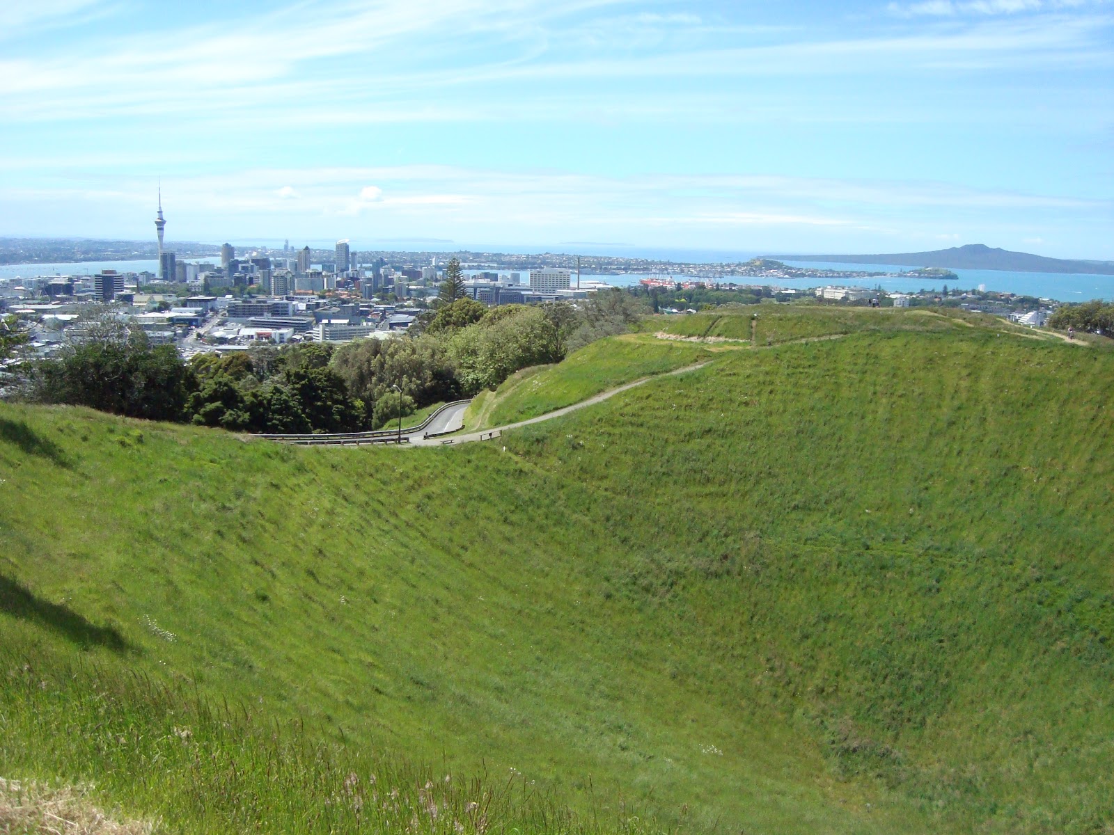 |
| Rangitoto Island (distance right) and Auckland from Mount Eden |
It starts off with a news bulletin saying an eruption is
imminent, their sensors have picked up big movements in the ground and everyone
is evacuating. You see blocked roads as people try to leave and a volcanologist
is explaining how they are certain something will happen very soon. As it goes
on you can see steam rising from the sea in front of Rangitoto Island through
the ‘windows’, there’s an earth tremor and the whole room receives a realistic
jolt, then suddenly the TV goes off and an eruption starts with flames shooting
out of the sea. It builds up into a huge cloud, which collapses and sends a
pyroclastic flow heading out in all directions, including straight for us. It
comes at an incredible speed, the noise is really loud and as we’re enveloped
in ash there’s another violent jolt and everything goes black. After a while
there’s a title called ‘Aftermath’ and you have a view after the ash has
settled that see’s Auckland in ruins, everything covered in thick ash. A man appears
(not a real man, its cinema!), who is some official who tries to calm and put
things into perspective saying how small the chances are, but it really makes
you think. Auckland apparently has very good planning in place for when the
next eruption occurs and they are confident they will be able to give
sufficient warning as everything is very closely monitored.
I’m going to put this next bit in green type as it might be
a bit boring for some, so if you’re not interested flick down to the end of the
green.
I always knew that the geology
of the North Island differs hugely to the geology of the South Island, but
never understood why. The North Island is full of volcano’s, hot mud pools and
geysers (well not all of it, but there’s a lot of them), but the South Island
has very few volcano’s but a ridge of very high mountains, called the Southern
Alps. This is apparently due to NZ being ‘twisted’.
We’ve all heard of the Pacific ‘Ring
of Fire’ and North Island NZ sits on the edge of this. The huge Pacific
Tectonic Plate is gradually moving West and is being subducted (pushed
underneath) plates that comprise Asia and Australia. North Island NZ is on the ‘Indo-Australian
Plate’ and, as the Pacific plate is subducted, it takes down into the mantle
rocks that contain lots of water. As they melt, the water turns to steam and it
can go off like an exploding kettle. Eruptions of this nature are usually very
explosive affairs, not gentle moving streams of lava, but massive explosions
with boulders and rock being hurled into the sky with lots of ash and poisonous
gas. Witness the recent and ongoing eruption of Mount Tongariro (I heard it
erupted again the other day – we’ll be going to see that on the second half of
our 6 months here).
The South Island, however, is on
the Pacific Plate, moving West and the Indo-Australian plate is moving North.
Where they meet they are almost sliding past each other, with a bit of a twist
and it is this sliding that has risen the Southern Alps. This is called an ‘Orogenic
Belt’ and, as very little rock is subducted, there are few volcano’s, but more
earthquakes as the plates ‘slide’ against each other. Witness the recent
earthquake in Christchurch.
Today we had to get up very early which wasn’t part of my
plan, having had a bad nights sleep a good and then a bad (here’s hoping for a
good tonight!) in order to catch the 07.30 ferry, there were two benefits to
this one it was cheaper ($17 rather than $27) and two it meant we could be up
and down the ‘hill’ before it got too hot. The alarm went off at 06.15, sadly I
was already awake, and had been downstairs reading till midnight thirty!
Anyway, off we trotted to the harbour, got the ferry and 30
mins later we were storming up to the summit of Rangitoto, we reached the
summit having made a slight detour to look at some lava tubes,

 |
| studying oysters on the black lava of Rangitito beach |
one of which was
big enough to walk through. Summit is an odd word for a volcano, because yes
there obviously is a point that is higher than any other, but there is also a
whole rim to walk round, we did this, and walked off across the island to a
small bridge that joins it with Motutapu a much older island, the difference in
appearance is startling, the first hard black lava beds, with some trees, quite
a lot in some places, almost none in others, and the second lush and green and rolling,
the eruption caused nice nutrients to fall on Motutapu making it more fertile.I think B would have liked to walk some way across this island, but walking on
the beads of lava was jolly hard work, and my shoes were already feeling uncomfortable,
so we veered off to find the coastal path round the south of Rangitoto.
 |
| crossing the bridge to fertile Motutapu |
We spoke to a really interesting bloke at this point ‘a pom
like us’, though he didn’t sound like it, gave us lots of useful tips on NZ,
where to go what to see. Said it was a shame we weren’t going to see the Pohutakawa
trees in flower up the coast as they turn the whole area red for Christmas! I
also asked him about foraging as there were loads of oysters on the beach, and we
later saw mussels too! I’m looking forward to that bit of the trip!
The coastal path wasn’t very coastal, was very pretty, but
not with the views of the sea I’d wanted, and when we came out of the trees, it
was a bit muddy and mangrove swampy, another first for us. I’d had enough by
this point as the harbour came into view, we arrived at 14.00 just in time for
the 14.15 ferry.
Walked out of the ferry terminal to see loads of people at
the end of the street, I remembered seeing signs for the Farmers Market
Christmas Parade, so thought we’d better have a look. That was easier said than
done, as there were LOTS of people, by the time we’d seen Mickey and Minnie and
‘The Cat in the Hat’ but no sign of Santa we gave up and walked back up the big
hill home. (Santa was there at the end apparently) All in all we reckon we
probably walked 15 miles, on hard unforgiving ground, no wonder my feet hurt!
 |
| the red 'Christmas Tree' of an early flowering Pohutakawa |
Off tomorrow to Christchurch to see the van for the first time,
I hope we fit in with all our stuff, or only one of us may come out of this
alive…..
No comments:
Post a Comment